
In the rugged terrain of McCaysville, GA, and the surrounding tri-state area, land clearing services have traditionally been challenging endeavors. Property owners often faced imprecise results, unexpected costs, and environmental concerns when clearing land for construction, creating trails, or managing vegetation. However, a technological revolution is changing how we approach forestry mulching and land clearing – GPS guidance systems.
At Big Frog Forestry Mulching, we’re at the forefront of this transformation, utilizing advanced GPS technology to deliver precision results that protect your soil, reduce erosion, and preserve valuable ecosystem components while efficiently clearing your land.
How GPS Technology Transforms Land Clearing Operations
GPS (Global Positioning System) technology has revolutionized countless industries, and forestry mulching is no exception. When integrated with modern land clearing equipment and machines, GPS provides unprecedented accuracy, efficiency, and environmental benefits.
Precision Boundary Mapping for Better Land Services
One of the most significant advantages of GPS-guided land clearing is the ability to establish and follow precise property boundaries, whether you’re clearing land for a new driveway, removing invasive species, or creating firebreaks for fire mitigation.
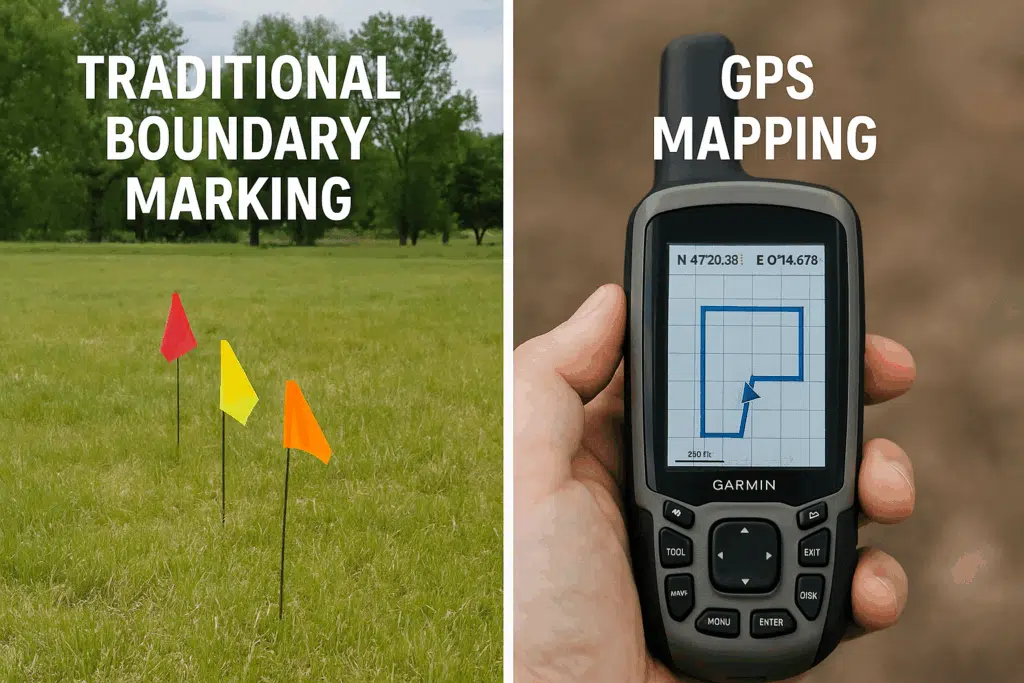
Traditional land clearing methods often relied on physical markers like fence lines, visual estimation, and operator judgment – all subject to human error. In mountainous terrain like McCaysville, where property lines may cross challenging landscapes, this imprecision could lead to:
- Accidentally clearing beyond property boundaries
- Leaving sections with unwanted brush or vegetation
- Disputes with neighboring property owners
- Potential legal complications with land development
GPS-guided systems eliminate these concerns by using satellite positioning accurate to within inches. Property boundaries are programmed into the system before work begins, creating invisible but precise digital fences that our tractor operators cannot cross accidentally.
Enhanced Vegetation and Brush Management
Not all vegetation clearing projects require complete removal of trees and understory growth. Many property owners in the North Georgia mountains want to preserve certain trees or natural features while clearing brush or invasive species. GPS technology makes selective clearing significantly more precise.
With GPS-guided forestry mulching, our operators can:
- Program exact clearing patterns around valuable trees and shrubs
- Create precise firebreaks at optimal distances from structures for wildfire protection
- Maintain specific buffer zones near water features to prevent soil erosion
- Follow complex clearing designs for landscape development or agriculture projects
- Selectively remove invasive species while preserving native vegetation
This level of precision was previously achievable only through painstaking manual marking and highly skilled operator work. Now, the technology ensures consistent results regardless of terrain challenges or visibility conditions, turning unwanted vegetation into beneficial mulch that returns organic matter and nutrients to your soil.
Improved Efficiency and Cost Effectiveness in Land Services
The efficiency gains from GPS-guided land clearing translate directly to cost savings for property owners in McCaysville and surrounding areas. When operators know exactly where to clear and where to avoid, the entire process becomes streamlined:
- Reduced project time through optimized clearing paths for the mulching machine
- Minimized fuel consumption through efficient equipment routing
- Decreased labor costs with faster project completion
- Lower risk of costly mistakes or property damage
- Reduced need for additional excavation or tree services
A project that might have taken days with traditional logging or demolition methods can often be completed in hours with GPS-guided forestry mulching, particularly on larger properties where navigation efficiency becomes increasingly important for productivity.
Real-World Applications in McCaysville and the Tri-State Area
The mountainous terrain and diverse property types in McCaysville, GA, and the surrounding tri-state area make it an ideal region to showcase the benefits of GPS-guided land clearing. Here are some specific applications where this technology is making a significant difference:
Creating Precise Firebreaks for Wildfire Protection
In the fire-prone forests of North Georgia, creating effective firebreaks is essential for property protection and fire mitigation. GPS-guided forestry mulching allows for the creation of firebreaks with consistent width and strategic placement.
The technology enables:
- Maintaining exact distance requirements from structures
- Creating curved or irregular firebreaks that follow topographical features
- Ensuring complete connectivity between firebreak sections
- Documenting cleared areas for insurance or compliance purposes
With climate change increasing wildfire risks in the Southeast, these precision firebreaks provide critical protection for mountain homes and cabins while preserving the overall forest management goals of your property.
Developing Trail Systems on Recreational Properties
Many property owners in the McCaysville area purchase land for recreational purposes, including hunting, ATV riding, or hiking. Creating trail systems through dense forest requires precision to ensure proper connectivity, appropriate width, and minimal disturbance to wildlife habitat.
GPS-guided clearing allows for:
- Pre-planned trail networks designed on digital maps
- Consistent trail widths regardless of terrain challenges
- Precise connections at trail intersections
- Minimal disturbance to surrounding vegetation and ecosystem
- Better drainage planning to prevent erosion along trails
The result is a professional-quality trail system that enhances property enjoyment while maintaining ecological balance and biodiversity.
Precision Clearing for New Construction and Infrastructure
When preparing land for new home construction, driveways, or infrastructure in the mountains, precision matters. Overclearing wastes resources and can create soil erosion problems, while underclearing may require costly secondary work.
GPS-guided land clearing provides:
- Exact adherence to architectural site plans for development
- Precise clearing for driveways, home sites, and utility corridors
- Preservation of specified trees and natural features
- Documentation for building permit compliance
- Targeted removal of tree stumps where needed
- Proper site preparation without excessive topsoil disturbance
This precision is particularly valuable in environmentally sensitive areas or properties with strict development guidelines that require minimal site disturbance.
Pipeline and Utility Corridor Maintenance
For properties with utilities or pipelines, GPS-guided forestry mulching provides precise corridor maintenance without over-clearing:
- Exact adherence to right-of-way boundaries
- Selective removal of problematic vegetation while preserving ground cover
- Minimal soil disturbance to prevent erosion along slopes
- Creation of mulch ground cover that suppresses future unwanted growth
- Reduced risk to underground infrastructure through precise machine operation
This approach is more environmentally friendly than traditional clearing methods, preserving soil structure while effectively maintaining these essential corridors.
The Technology Behind GPS-Guided Forestry Mulching
Understanding the technology behind GPS-guided forestry mulching helps property owners appreciate the value and capabilities of this advanced approach to clearing land.
Equipment Integration and Hydraulics
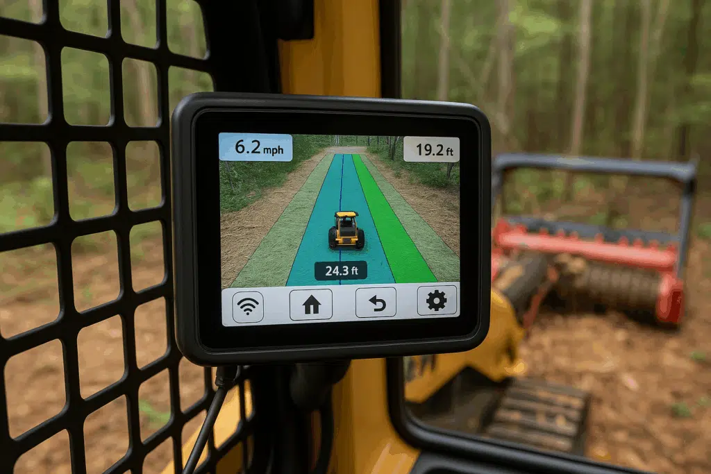
Modern forestry mulching equipment can be fitted with specialized GPS receivers and onboard computers that process location data in real-time. These systems include:
- High-precision GPS receivers with sub-inch accuracy
- Ruggedized onboard computers with specialized mapping software
- Digital displays showing real-time position and clearing boundaries
- Advanced hydraulics systems that respond to GPS positioning
- Data logging systems that record work completed
This integration allows operators to see exactly where they are on the property relative to planned clearing boundaries and obstacles, while precision hydraulics ensure the mulching head engages only where needed.
Digital Mapping and Project Planning for Site Preparation
Before any equipment arrives on site, GPS-guided projects begin with detailed digital mapping:
- Property boundaries are imported from survey data or precisely mapped
- Clearing areas are defined based on the property owner’s requirements
- Preservation zones around trees, waterways, or structures are marked
- Optimal equipment paths are calculated for maximum efficiency
- Soil conditions and terrain features are noted to minimize erosion risk
This digital preparation ensures that when work begins, every aspect of the project has been carefully planned and programmed for optimal site preparation.
Real-Time Operator Guidance
During the clearing operation, operators receive continuous guidance through visual displays showing:
- Current position on the property
- Proximity to boundaries or preservation zones
- Completed versus remaining areas
- Optimal path suggestions
- Terrain challenges and slope information
Some advanced systems even include steering assistance or implement controls that automatically adjust based on position, further enhancing precision and reducing operator fatigue during complex clearing operations.
Environmental Benefits of GPS-Guided Precision Clearing
Beyond the operational advantages, GPS-guided forestry mulching offers significant environmental benefits that are particularly important in the ecologically diverse North Georgia mountains.
Minimized Soil Disturbance and Erosion Control
Precise equipment routing means less unnecessary movement across the property, resulting in:
- Reduced soil compaction
- Decreased erosion potential and better erosion control
- Preserved root systems of remaining vegetation
- Better conditions for natural regeneration
- Protection of valuable topsoil
This minimized impact is especially important on sloped properties where soil erosion control is a primary concern for sustainability and environmental compliance.
Wildlife Habitat Preservation and Biodiversity
The ability to precisely define clearing boundaries allows for intentional habitat preservation:
- Wildlife corridors can be maintained between cleared areas
- Riparian zones along streams can be protected with exact buffer distances
- Specific habitat trees or vegetation clusters can be preserved
- Edge habitats beneficial to many species can be intentionally created
- Understory vegetation important to local organisms can be selectively maintained
This precision allows property owners to balance development needs with conservation goals and maintain biodiversity on their land.
Converting Vegetation to Beneficial Mulch
Unlike traditional land clearing that requires burning or hauling away debris, forestry mulching converts unwanted vegetation directly into mulch that:
- Returns organic matter to the soil
- Improves soil fertility and nutrient content
- Reduces erosion by providing ground cover
- Suppresses unwanted invasive species growth
- Creates a natural-looking finished product
- Eliminates the air quality issues associated with burning
This environmentally friendly approach to dealing with cleared vegetation aligns with sustainable land management practices and supports long-term ecosystem health.
Big Frog’s Approach to GPS-Guided Forestry Mulching
At Big Frog Forestry Mulching, we’ve invested in state-of-the-art GPS technology to provide McCaysville property owners with the most precise and efficient land clearing services available.
Our GPS Technology Advantage
Our equipment features:
- High-precision GPS receivers with real-time correction capabilities
- Advanced mapping software for detailed project planning
- Trained operators skilled in both the technology and forestry practices
- Data capture systems that provide documentation of completed work
- Specialized mulching heads that produce consistent, beneficial mulch
This technological investment allows us to tackle projects of any complexity with confidence and precision, whether you need to clear land for a new construction project or manage vegetation on an existing property.
The Customer Service Difference
For property owners in McCaysville and the tri-state area, our GPS-guided approach means:
- Detailed pre-project planning with digital visualization
- Confidence that boundaries and preservation areas will be respected
- Consistent results regardless of terrain challenges
- Professional documentation of completed work
- Responsive customer service throughout the project
We’re committed to providing exceptional service from the free quote stage through project completion, ensuring your land clearing needs are met with precision and care.
The Future of Land Clearing Technology
As GPS and related technologies continue to advance, we can expect even greater precision and capabilities in land clearing operations. Some emerging trends include:
- Integration with drone mapping for enhanced pre-project planning
- Augmented reality displays showing underground utilities during clearing
- Automated machine learning systems that optimize clearing patterns
- Remote monitoring capabilities for property owners
- Advanced hydraulics systems with even greater precision control
- Enhanced mulching heads that produce finer, more beneficial wood mulch
At Big Frog Forestry Mulching, we remain committed to staying at the forefront of these technological advancements to provide McCaysville property owners with the most effective land clearing solutions available.
Transform Your Property with Precision GPS-Guided Clearing
If you’re considering a land clearing or forestry mulching project in McCaysville or the surrounding tri-state area, GPS-guided precision can make a significant difference in your results. From creating perfect building sites to establishing trail systems or managing vegetation, this technology ensures your vision is executed with unmatched accuracy.
Our services are ideal for:
- New construction site preparation
- Driveway and access road creation
- Invasive species removal
- Fire mitigation through firebreak creation
- Trail development for recreational properties
- Fence line and property boundary clearing
- Agricultural land development
- Habitat management and wildlife conservation
Contact Big Frog Forestry Mulching today at (706) 851-3524 to schedule your free quote. Our experienced team is ready to provide a consultation for your specific project needs, explaining how our GPS-guided forestry mulching can transform your property while protecting your soil, reducing erosion risks, and maintaining the natural beauty of your land.